|
|
|||||||||||||||||
| Point ID: 5830 | Downloads | Plots | Site Data | Code: 09EC001 |
|
|
|||||||||||||||||
| Download | |
|---|---|
| Site Descriptor Information | Site Time Series Data |
| Link to all available data | |
| View: | Time Series | All |
| Units: | mm |
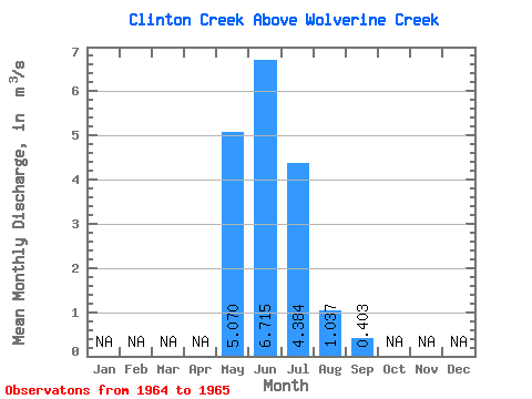
| Statistic | Jan | Feb | Mar | Apr | May | Jun | Jul | Aug | Sep | Oct | Nov | Dec | Annual |
|---|---|---|---|---|---|---|---|---|---|---|---|---|---|
| Mean | 5.07 | 6.71 | 4.38 | 1.04 | 0.40 | ||||||||
| Standard Deviation | 1.21 | 5.68 | 1.11 | 0.28 | |||||||||
| Min | 5.07 | 5.86 | 0.37 | 0.25 | 0.21 | ||||||||
| Max | 5.07 | 7.57 | 8.40 | 1.82 | 0.60 | ||||||||
| Coefficient of Variation | 0.18 | 1.30 | 1.07 | 0.68 |
 Return to R-Arctic Net Home Page