|
|
| Point ID: 5830 | Downloads | Plots | Site Data | Code: 09EC001 |
|
| Download | |
|---|---|
| Site Descriptor Information | Site Time Series Data |
| Link to all available data | |
|
|
|
| View: | Statistics | All |
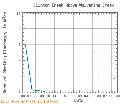
| Units: | mm |
| Year | Jan | Feb | Mar | Apr | May | Jun | Jul | Aug | Sep | Oct | Nov | Dec | Annual | 1964 | 5.86 | 0.37 | 0.25 | 0.21 | 1965 | 5.07 | 7.57 | 8.40 | 1.82 | 0.60 |
|---|
 Return to R-Arctic Net Home Page