|
|
|||||||||||||||||
| Point ID: 5828 | Downloads | Plots | Site Data | Other Close Sites | Code: 09EB002 |
|
|
|||||||||||||||||
| Download | |
|---|---|
| Site Descriptor Information | Site Time Series Data |
| Link to all available data | |
| View: | Time Series | All |
| Units: | mm |
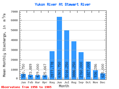
| Statistic | Jan | Feb | Mar | Apr | May | Jun | Jul | Aug | Sep | Oct | Nov | Dec | Annual |
|---|---|---|---|---|---|---|---|---|---|---|---|---|---|
| Mean | 560.75 | 473.89 | 429.00 | 425.67 | 2877.78 | 6363.75 | 5016.25 | 3886.25 | 2760.00 | 1827.00 | 936.29 | 625.00 | 2374.14 |
| Standard Deviation | 98.17 | 88.18 | 67.16 | 55.64 | 996.28 | 2463.46 | 1190.33 | 701.14 | 490.56 | 485.27 | 192.32 | 110.04 | 271.89 |
| Min | 410.00 | 363.00 | 352.00 | 321.00 | 1490.00 | 3700.00 | 3010.00 | 2730.00 | 1930.00 | 973.00 | 584.00 | 436.00 | 2106.25 |
| Max | 683.00 | 623.00 | 542.00 | 510.00 | 4230.00 | 11000.00 | 6530.00 | 4810.00 | 3300.00 | 2450.00 | 1150.00 | 757.00 | 2723.67 |
| Coefficient of Variation | 0.17 | 0.19 | 0.16 | 0.13 | 0.35 | 0.39 | 0.24 | 0.18 | 0.18 | 0.27 | 0.20 | 0.18 | 0.12 |
| Other Close Sites | ||||||
|---|---|---|---|---|---|---|
| PointID | Latitude | Longitude | Drainage Area | Source | Name | |
| 5822 | "STEWART RIVER AT THE MOUTH" | 63.28 | 2230226 | Hydat | ||
 Return to R-Arctic Net Home Page