|
|
|||||||||||||||||
| Point ID: 5822 | Downloads | Plots | Site Data | Other Close Sites | Code: 09DD003 |
|
|
|||||||||||||||||
| Download | |
|---|---|
| Site Descriptor Information | Site Time Series Data |
| Link to all available data | |
| View: | Time Series | All |
| Units: | mm |
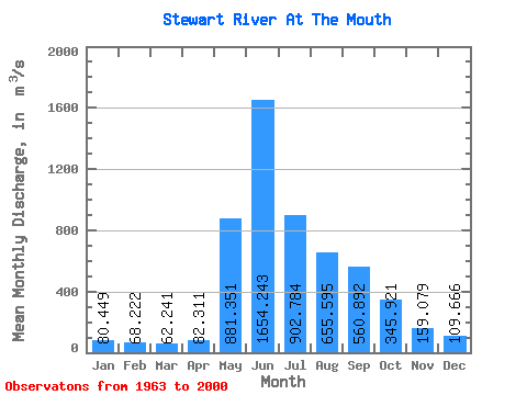
| Statistic | Jan | Feb | Mar | Apr | May | Jun | Jul | Aug | Sep | Oct | Nov | Dec | Annual |
|---|---|---|---|---|---|---|---|---|---|---|---|---|---|
| Mean | 80.45 | 68.22 | 62.24 | 82.31 | 881.35 | 1654.24 | 902.78 | 655.60 | 560.89 | 345.92 | 159.08 | 109.67 | 463.23 |
| Standard Deviation | 14.49 | 12.02 | 11.75 | 26.41 | 284.61 | 573.66 | 268.64 | 198.21 | 184.75 | 102.14 | 38.79 | 23.62 | 88.34 |
| Min | 52.80 | 39.70 | 35.90 | 42.40 | 220.00 | 919.00 | 491.00 | 304.00 | 234.00 | 160.00 | 79.00 | 70.90 | 333.10 |
| Max | 128.00 | 106.00 | 90.20 | 152.00 | 1570.00 | 3940.00 | 1690.00 | 1200.00 | 1050.00 | 594.00 | 263.00 | 176.00 | 735.03 |
| Coefficient of Variation | 0.18 | 0.18 | 0.19 | 0.32 | 0.32 | 0.35 | 0.30 | 0.30 | 0.33 | 0.29 | 0.24 | 0.21 | 0.19 |
| Other Close Sites | ||||||
|---|---|---|---|---|---|---|
| PointID | Latitude | Longitude | Drainage Area | Source | Name | |
| 5828 | "YUKON RIVER AT STEWART RIVER" | 63.31 | 2233789 | Hydat | ||
 Return to R-Arctic Net Home Page