|
|
|||||||||||||||||
| Point ID: 5805 | Downloads | Plots | Site Data | Code: 09BB002 |
|
|
|||||||||||||||||
| Download | |
|---|---|
| Site Descriptor Information | Site Time Series Data |
| Link to all available data | |
| View: | Time Series | All |
| Units: | mm |
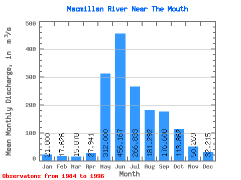
| Statistic | Jan | Feb | Mar | Apr | May | Jun | Jul | Aug | Sep | Oct | Nov | Dec | Annual |
|---|---|---|---|---|---|---|---|---|---|---|---|---|---|
| Mean | 21.80 | 17.63 | 15.88 | 27.94 | 312.00 | 456.17 | 266.83 | 181.29 | 176.61 | 113.86 | 50.27 | 32.22 | 140.53 |
| Standard Deviation | 6.11 | 5.23 | 4.78 | 12.91 | 105.23 | 165.55 | 88.99 | 55.88 | 76.95 | 33.49 | 12.21 | 8.04 | 25.97 |
| Min | 12.60 | 8.24 | 5.22 | 6.69 | 165.00 | 205.00 | 144.00 | 84.70 | 67.40 | 59.10 | 28.20 | 18.70 | 99.44 |
| Max | 31.90 | 25.90 | 22.50 | 48.80 | 541.00 | 809.00 | 438.00 | 255.00 | 357.00 | 189.00 | 73.60 | 47.10 | 179.00 |
| Coefficient of Variation | 0.28 | 0.30 | 0.30 | 0.46 | 0.34 | 0.36 | 0.33 | 0.31 | 0.44 | 0.29 | 0.24 | 0.25 | 0.18 |
 Return to R-Arctic Net Home Page