|
|
|||||||||||||||||
| Point ID: 5805 | Downloads | Plots | Site Data | Code: 09BB002 |
|
|
|||||||||||||||||
| Download | |
|---|---|
| Site Descriptor Information | Site Time Series Data |
| Link to all available data | |
| View: | Time Series | All |
| Units: | m3/s |
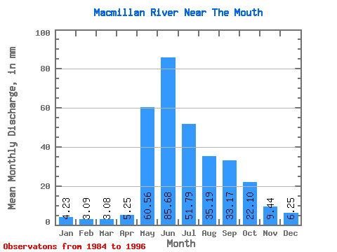
| Statistic | Jan | Feb | Mar | Apr | May | Jun | Jul | Aug | Sep | Oct | Nov | Dec | Annual |
|---|---|---|---|---|---|---|---|---|---|---|---|---|---|
| Mean | 4.23 | 3.12 | 3.08 | 5.25 | 60.55 | 85.68 | 51.78 | 35.18 | 33.17 | 22.10 | 9.44 | 6.25 | 321.39 |
| Standard Deviation | 1.19 | 0.93 | 0.93 | 2.42 | 20.42 | 31.09 | 17.27 | 10.84 | 14.45 | 6.50 | 2.29 | 1.56 | 59.38 |
| Min | 2.44 | 1.46 | 1.01 | 1.26 | 32.02 | 38.50 | 27.94 | 16.44 | 12.66 | 11.47 | 5.30 | 3.63 | 227.42 |
| Max | 6.19 | 4.58 | 4.37 | 9.17 | 104.98 | 151.95 | 85.00 | 49.48 | 67.05 | 36.68 | 13.82 | 9.14 | 409.37 |
| Coefficient of Variation | 0.28 | 0.30 | 0.30 | 0.46 | 0.34 | 0.36 | 0.33 | 0.31 | 0.44 | 0.29 | 0.24 | 0.25 | 0.18 |
 Return to R-Arctic Net Home Page