|
|
|||||||||||||||||
| Point ID: 5786 | Downloads | Plots | Site Data | Code: 09AA012 |
|
|
|||||||||||||||||
| Download | |
|---|---|
| Site Descriptor Information | Site Time Series Data |
| Link to all available data | |
| View: | Time Series | All |
| Units: | mm |
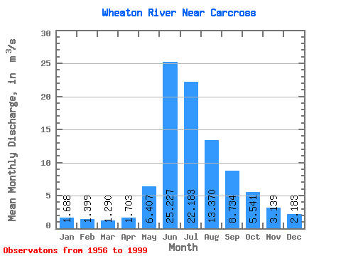
| Statistic | Jan | Feb | Mar | Apr | May | Jun | Jul | Aug | Sep | Oct | Nov | Dec | Annual |
|---|---|---|---|---|---|---|---|---|---|---|---|---|---|
| Mean | 1.69 | 1.40 | 1.29 | 1.70 | 6.41 | 25.23 | 22.18 | 13.37 | 8.73 | 5.54 | 3.14 | 2.18 | 7.78 |
| Standard Deviation | 0.41 | 0.32 | 0.27 | 0.78 | 3.95 | 6.97 | 6.42 | 3.59 | 2.68 | 1.73 | 0.96 | 0.61 | 1.48 |
| Min | 0.52 | 0.35 | 0.38 | 0.51 | 3.07 | 12.10 | 12.20 | 7.36 | 5.02 | 2.37 | 1.73 | 1.05 | 5.10 |
| Max | 2.60 | 1.97 | 1.85 | 4.83 | 16.80 | 36.40 | 40.50 | 20.00 | 14.20 | 9.31 | 6.10 | 4.07 | 12.29 |
| Coefficient of Variation | 0.24 | 0.23 | 0.21 | 0.46 | 0.62 | 0.28 | 0.29 | 0.27 | 0.31 | 0.31 | 0.31 | 0.28 | 0.19 |
 Return to R-Arctic Net Home Page