|
|
|||||||||||||||||
| Point ID: 5786 | Downloads | Plots | Site Data | Code: 09AA012 |
|
|
|||||||||||||||||
| Download | |
|---|---|
| Site Descriptor Information | Site Time Series Data |
| Link to all available data | |
| View: | Time Series | All |
| Units: | m3/s |
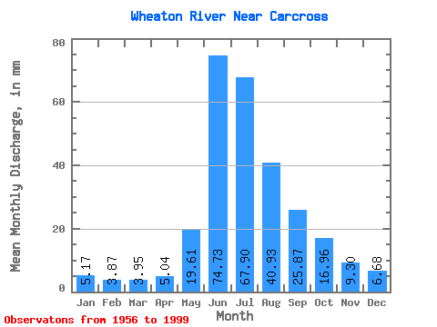
| Statistic | Jan | Feb | Mar | Apr | May | Jun | Jul | Aug | Sep | Oct | Nov | Dec | Annual |
|---|---|---|---|---|---|---|---|---|---|---|---|---|---|
| Mean | 5.17 | 3.90 | 3.95 | 5.05 | 19.61 | 74.73 | 67.89 | 40.92 | 25.87 | 16.96 | 9.30 | 6.68 | 280.44 |
| Standard Deviation | 1.25 | 0.89 | 0.83 | 2.30 | 12.10 | 20.66 | 19.66 | 11.00 | 7.93 | 5.29 | 2.86 | 1.86 | 53.22 |
| Min | 1.58 | 0.96 | 1.17 | 1.51 | 9.40 | 35.84 | 37.34 | 22.53 | 14.87 | 7.25 | 5.12 | 3.21 | 183.86 |
| Max | 7.96 | 5.49 | 5.66 | 14.31 | 51.42 | 107.83 | 123.95 | 61.21 | 42.06 | 28.49 | 18.07 | 12.46 | 443.40 |
| Coefficient of Variation | 0.24 | 0.23 | 0.21 | 0.46 | 0.62 | 0.28 | 0.29 | 0.27 | 0.31 | 0.31 | 0.31 | 0.28 | 0.19 |
 Return to R-Arctic Net Home Page