|
|
|||||||||||||||||
| Point ID: 574 | Downloads | Plots | Site Data | Code: 06AC001 |
|
|
|||||||||||||||||
| Download | |
|---|---|
| Site Descriptor Information | Site Time Series Data |
| Link to all available data | |
| View: | Time Series | All |
| Units: | mm |
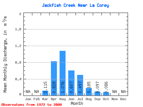
| Statistic | Jan | Feb | Mar | Apr | May | Jun | Jul | Aug | Sep | Oct | Nov | Dec | Annual |
|---|---|---|---|---|---|---|---|---|---|---|---|---|---|
| Mean | 0.12 | 0.83 | 1.08 | 0.61 | 0.50 | 0.18 | 0.10 | 0.09 | |||||
| Standard Deviation | 0.09 | 0.85 | 1.89 | 1.27 | 0.96 | 0.27 | 0.15 | 0.22 | |||||
| Min | 0.00 | 0.02 | 0.00 | 0.00 | 0.00 | 0.00 | 0.00 | 0.00 | |||||
| Max | 0.27 | 4.74 | 9.80 | 6.29 | 4.26 | 1.06 | 0.68 | 1.20 | |||||
| Coefficient of Variation | 0.78 | 1.03 | 1.75 | 2.09 | 1.94 | 1.47 | 1.59 | 2.60 |
 Return to R-Arctic Net Home Page