|
|
|||||||||||||||||
| Point ID: 574 | Downloads | Plots | Site Data | Code: 06AC001 |
|
|
|||||||||||||||||
| Download | |
|---|---|
| Site Descriptor Information | Site Time Series Data |
| Link to all available data | |
| View: | Time Series | All |
| Units: | m3/s |
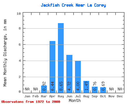
| Statistic | Jan | Feb | Mar | Apr | May | Jun | Jul | Aug | Sep | Oct | Nov | Dec | Annual |
|---|---|---|---|---|---|---|---|---|---|---|---|---|---|
| Mean | 0.63 | 4.39 | 5.89 | 3.21 | 2.72 | 1.01 | 0.51 | 0.47 | |||||
| Standard Deviation | 0.49 | 4.52 | 10.32 | 6.72 | 5.28 | 1.49 | 0.82 | 1.22 | |||||
| Min | 0.00 | 0.09 | 0.01 | 0.00 | 0.00 | 0.00 | 0.00 | 0.00 | |||||
| Max | 1.49 | 25.12 | 53.67 | 33.34 | 23.33 | 5.80 | 3.59 | 6.57 | |||||
| Coefficient of Variation | 0.78 | 1.03 | 1.75 | 2.09 | 1.94 | 1.47 | 1.59 | 2.60 |
 Return to R-Arctic Net Home Page