|
|
|||||||||||||||||
| Point ID: 5616 | Downloads | Plots | Site Data | Code: 07LE003 |
|
|
|||||||||||||||||
| Download | |
|---|---|
| Site Descriptor Information | Site Time Series Data |
| Link to all available data | |
| View: | Time Series | All |
| Units: | mm |
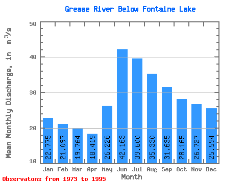
| Statistic | Jan | Feb | Mar | Apr | May | Jun | Jul | Aug | Sep | Oct | Nov | Dec | Annual |
|---|---|---|---|---|---|---|---|---|---|---|---|---|---|
| Mean | 22.77 | 21.10 | 19.76 | 18.42 | 26.23 | 42.16 | 39.60 | 35.33 | 31.64 | 28.16 | 26.73 | 25.59 | 28.63 |
| Standard Deviation | 8.71 | 7.46 | 6.31 | 5.21 | 10.36 | 14.95 | 11.39 | 11.20 | 12.89 | 13.07 | 12.56 | 10.79 | 8.75 |
| Min | 8.32 | 8.25 | 8.25 | 8.84 | 10.60 | 17.80 | 18.40 | 15.70 | 11.80 | 9.56 | 8.53 | 8.48 | 11.91 |
| Max | 39.20 | 34.90 | 30.80 | 27.80 | 44.30 | 72.20 | 62.70 | 56.80 | 62.60 | 58.30 | 50.80 | 44.20 | 42.74 |
| Coefficient of Variation | 0.38 | 0.35 | 0.32 | 0.28 | 0.40 | 0.35 | 0.29 | 0.32 | 0.41 | 0.46 | 0.47 | 0.42 | 0.31 |
 Return to R-Arctic Net Home Page