|
|
|||||||||||||||||
| Point ID: 5616 | Downloads | Plots | Site Data | Code: 07LE003 |
|
|
|||||||||||||||||
| Download | |
|---|---|
| Site Descriptor Information | Site Time Series Data |
| Link to all available data | |
| View: | Time Series | All |
| Units: | m3/s |
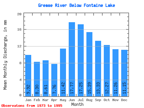
| Statistic | Jan | Feb | Mar | Apr | May | Jun | Jul | Aug | Sep | Oct | Nov | Dec | Annual |
|---|---|---|---|---|---|---|---|---|---|---|---|---|---|
| Mean | 9.92 | 8.37 | 8.61 | 7.76 | 11.42 | 17.77 | 17.24 | 15.38 | 13.33 | 12.26 | 11.26 | 11.14 | 146.91 |
| Standard Deviation | 3.79 | 2.96 | 2.75 | 2.19 | 4.51 | 6.30 | 4.96 | 4.88 | 5.43 | 5.69 | 5.29 | 4.70 | 44.89 |
| Min | 3.62 | 3.27 | 3.59 | 3.73 | 4.62 | 7.50 | 8.01 | 6.84 | 4.97 | 4.16 | 3.59 | 3.69 | 61.14 |
| Max | 17.07 | 13.85 | 13.41 | 11.72 | 19.29 | 30.43 | 27.30 | 24.73 | 26.38 | 25.39 | 21.41 | 19.25 | 219.34 |
| Coefficient of Variation | 0.38 | 0.35 | 0.32 | 0.28 | 0.40 | 0.35 | 0.29 | 0.32 | 0.41 | 0.46 | 0.47 | 0.42 | 0.31 |
 Return to R-Arctic Net Home Page