|
|
|||||||||||||||||
| Point ID: 5599 | Downloads | Plots | Site Data | Code: 06DC001 |
|
|
|||||||||||||||||
| Download | |
|---|---|
| Site Descriptor Information | Site Time Series Data |
| Link to all available data | |
| View: | Time Series | All |
| Units: | mm |
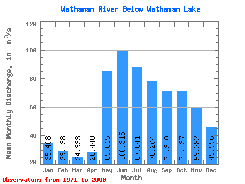
| Statistic | Jan | Feb | Mar | Apr | May | Jun | Jul | Aug | Sep | Oct | Nov | Dec | Annual |
|---|---|---|---|---|---|---|---|---|---|---|---|---|---|
| Mean | 35.41 | 29.14 | 24.93 | 28.45 | 85.81 | 100.31 | 87.84 | 78.20 | 71.31 | 71.14 | 59.28 | 46.00 | 57.75 |
| Standard Deviation | 11.38 | 8.79 | 6.80 | 11.00 | 39.10 | 49.45 | 43.33 | 44.72 | 35.75 | 42.77 | 28.61 | 16.97 | 18.21 |
| Min | 14.20 | 11.90 | 10.20 | 12.20 | 29.00 | 30.00 | 26.40 | 29.90 | 25.10 | 22.90 | 20.80 | 18.90 | 32.47 |
| Max | 58.30 | 48.00 | 39.70 | 60.50 | 172.00 | 215.00 | 200.00 | 246.00 | 167.00 | 222.00 | 140.00 | 82.90 | 101.88 |
| Coefficient of Variation | 0.32 | 0.30 | 0.27 | 0.39 | 0.46 | 0.49 | 0.49 | 0.57 | 0.50 | 0.60 | 0.48 | 0.37 | 0.32 |
 Return to R-Arctic Net Home Page