|
|
|||||||||||||||||
| Point ID: 5599 | Downloads | Plots | Site Data | Code: 06DC001 |
|
|
|||||||||||||||||
| Download | |
|---|---|
| Site Descriptor Information | Site Time Series Data |
| Link to all available data | |
| View: | Time Series | All |
| Units: | m3/s |
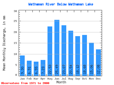
| Statistic | Jan | Feb | Mar | Apr | May | Jun | Jul | Aug | Sep | Oct | Nov | Dec | Annual |
|---|---|---|---|---|---|---|---|---|---|---|---|---|---|
| Mean | 9.30 | 6.97 | 6.55 | 7.23 | 22.53 | 25.49 | 23.06 | 20.53 | 18.12 | 18.68 | 15.06 | 12.08 | 178.70 |
| Standard Deviation | 2.99 | 2.10 | 1.79 | 2.80 | 10.27 | 12.56 | 11.38 | 11.74 | 9.09 | 11.23 | 7.27 | 4.46 | 56.35 |
| Min | 3.73 | 2.85 | 2.68 | 3.10 | 7.61 | 7.62 | 6.93 | 7.85 | 6.38 | 6.01 | 5.29 | 4.96 | 100.46 |
| Max | 15.31 | 11.48 | 10.42 | 15.37 | 45.16 | 54.63 | 52.51 | 64.59 | 42.44 | 58.29 | 35.58 | 21.77 | 315.24 |
| Coefficient of Variation | 0.32 | 0.30 | 0.27 | 0.39 | 0.46 | 0.49 | 0.49 | 0.57 | 0.50 | 0.60 | 0.48 | 0.37 | 0.32 |
 Return to R-Arctic Net Home Page