|
|
|||||||||||||||||
| Point ID: 5595 | Downloads | Plots | Site Data | Code: 06DA004 |
|
|
|||||||||||||||||
| Download | |
|---|---|
| Site Descriptor Information | Site Time Series Data |
| Link to all available data | |
| View: | Time Series | All |
| Units: | mm |
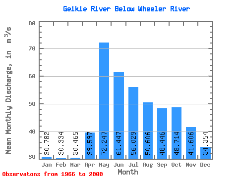
| Statistic | Jan | Feb | Mar | Apr | May | Jun | Jul | Aug | Sep | Oct | Nov | Dec | Annual |
|---|---|---|---|---|---|---|---|---|---|---|---|---|---|
| Mean | 30.78 | 30.33 | 30.46 | 39.60 | 72.25 | 61.45 | 56.03 | 50.61 | 48.45 | 48.71 | 41.61 | 34.35 | 45.53 |
| Standard Deviation | 9.67 | 10.33 | 9.97 | 14.19 | 19.05 | 19.07 | 19.34 | 19.34 | 22.24 | 23.41 | 15.04 | 10.48 | 10.92 |
| Min | 10.30 | 5.56 | 5.52 | 11.80 | 44.40 | 31.60 | 27.10 | 19.40 | 19.50 | 19.30 | 19.30 | 18.50 | 30.31 |
| Max | 53.90 | 54.40 | 53.70 | 89.10 | 112.00 | 119.00 | 109.00 | 117.00 | 120.00 | 136.00 | 85.40 | 64.00 | 74.02 |
| Coefficient of Variation | 0.31 | 0.34 | 0.33 | 0.36 | 0.26 | 0.31 | 0.34 | 0.38 | 0.46 | 0.48 | 0.36 | 0.30 | 0.24 |
 Return to R-Arctic Net Home Page