|
|
|||||||||||||||||
| Point ID: 5595 | Downloads | Plots | Site Data | Code: 06DA004 |
|
|
|||||||||||||||||
| Download | |
|---|---|
| Site Descriptor Information | Site Time Series Data |
| Link to all available data | |
| View: | Time Series | All |
| Units: | m3/s |
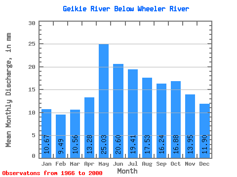
| Statistic | Jan | Feb | Mar | Apr | May | Jun | Jul | Aug | Sep | Oct | Nov | Dec | Annual |
|---|---|---|---|---|---|---|---|---|---|---|---|---|---|
| Mean | 10.66 | 9.57 | 10.55 | 13.28 | 25.03 | 20.60 | 19.41 | 17.53 | 16.25 | 16.88 | 13.95 | 11.90 | 185.89 |
| Standard Deviation | 3.35 | 3.26 | 3.45 | 4.76 | 6.60 | 6.39 | 6.70 | 6.70 | 7.46 | 8.11 | 5.04 | 3.63 | 44.57 |
| Min | 3.57 | 1.75 | 1.91 | 3.96 | 15.38 | 10.60 | 9.39 | 6.72 | 6.54 | 6.69 | 6.47 | 6.41 | 123.74 |
| Max | 18.67 | 17.17 | 18.60 | 29.88 | 38.80 | 39.90 | 37.76 | 40.53 | 40.24 | 47.12 | 28.64 | 22.17 | 302.19 |
| Coefficient of Variation | 0.31 | 0.34 | 0.33 | 0.36 | 0.26 | 0.31 | 0.34 | 0.38 | 0.46 | 0.48 | 0.36 | 0.30 | 0.24 |
 Return to R-Arctic Net Home Page