|
|
|||||||||||||||||
| Point ID: 5582 | Downloads | Plots | Site Data | Code: 06BB004 |
|
|
|||||||||||||||||
| Download | |
|---|---|
| Site Descriptor Information | Site Time Series Data |
| Link to all available data | |
| View: | Time Series | All |
| Units: | mm |
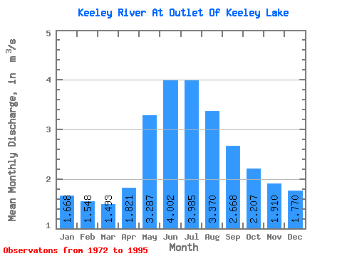
| Statistic | Jan | Feb | Mar | Apr | May | Jun | Jul | Aug | Sep | Oct | Nov | Dec | Annual |
|---|---|---|---|---|---|---|---|---|---|---|---|---|---|
| Mean | 1.67 | 1.55 | 1.49 | 1.82 | 3.29 | 4.00 | 3.98 | 3.37 | 2.67 | 2.21 | 1.91 | 1.77 | 2.49 |
| Standard Deviation | 0.99 | 0.80 | 0.63 | 0.69 | 1.92 | 2.72 | 2.18 | 2.18 | 1.83 | 1.57 | 1.33 | 1.12 | 1.20 |
| Min | 0.26 | 0.42 | 0.51 | 0.68 | 0.73 | 0.31 | 0.20 | 0.21 | 0.20 | 0.16 | 0.13 | 0.13 | 0.55 |
| Max | 4.68 | 3.94 | 3.26 | 3.29 | 9.36 | 10.40 | 8.82 | 9.51 | 6.69 | 6.04 | 5.48 | 4.92 | 4.84 |
| Coefficient of Variation | 0.59 | 0.52 | 0.42 | 0.38 | 0.58 | 0.68 | 0.55 | 0.65 | 0.69 | 0.71 | 0.69 | 0.63 | 0.48 |
 Return to R-Arctic Net Home Page