|
|
|||||||||||||||||
| Point ID: 5582 | Downloads | Plots | Site Data | Code: 06BB004 |
|
|
|||||||||||||||||
| Download | |
|---|---|
| Site Descriptor Information | Site Time Series Data |
| Link to all available data | |
| View: | Time Series | All |
| Units: | m3/s |
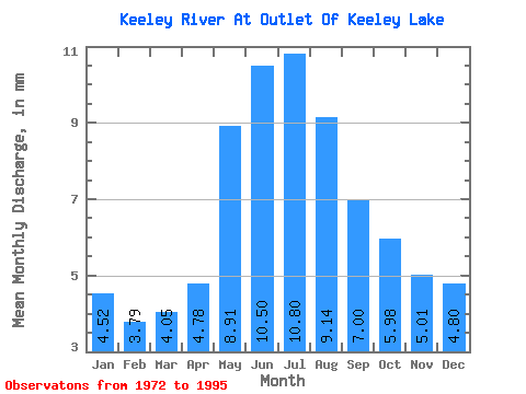
| Statistic | Jan | Feb | Mar | Apr | May | Jun | Jul | Aug | Sep | Oct | Nov | Dec | Annual |
|---|---|---|---|---|---|---|---|---|---|---|---|---|---|
| Mean | 4.38 | 3.70 | 3.92 | 4.63 | 8.63 | 10.17 | 10.46 | 8.85 | 6.78 | 5.79 | 4.85 | 4.65 | 77.16 |
| Standard Deviation | 2.61 | 1.91 | 1.66 | 1.74 | 5.03 | 6.91 | 5.72 | 5.71 | 4.65 | 4.12 | 3.37 | 2.94 | 37.21 |
| Min | 0.67 | 1.01 | 1.33 | 1.72 | 1.91 | 0.78 | 0.52 | 0.55 | 0.51 | 0.41 | 0.33 | 0.34 | 17.00 |
| Max | 12.29 | 9.43 | 8.56 | 8.36 | 24.57 | 26.43 | 23.16 | 24.97 | 17.00 | 15.86 | 13.93 | 12.92 | 149.75 |
| Coefficient of Variation | 0.59 | 0.52 | 0.42 | 0.38 | 0.58 | 0.68 | 0.55 | 0.65 | 0.69 | 0.71 | 0.69 | 0.63 | 0.48 |
 Return to R-Arctic Net Home Page