|
|
|||||||||||||||||
| Point ID: 5579 | Downloads | Plots | Site Data | Code: 06BA002 |
|
|
|||||||||||||||||
| Download | |
|---|---|
| Site Descriptor Information | Site Time Series Data |
| Link to all available data | |
| View: | Time Series | All |
| Units: | mm |
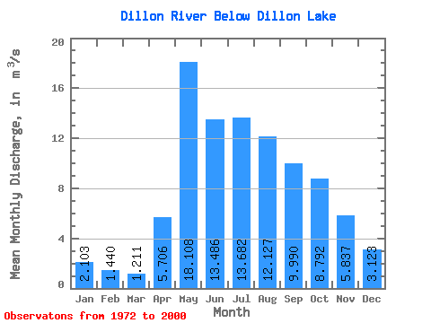
| Statistic | Jan | Feb | Mar | Apr | May | Jun | Jul | Aug | Sep | Oct | Nov | Dec | Annual |
|---|---|---|---|---|---|---|---|---|---|---|---|---|---|
| Mean | 2.10 | 1.44 | 1.21 | 5.71 | 18.11 | 13.49 | 13.68 | 12.13 | 9.99 | 8.79 | 5.84 | 3.12 | 7.88 |
| Standard Deviation | 1.66 | 1.06 | 0.78 | 4.23 | 16.87 | 9.20 | 10.33 | 10.90 | 8.46 | 6.84 | 3.84 | 1.86 | 4.16 |
| Min | 0.62 | 0.40 | 0.38 | 1.80 | 3.02 | 1.08 | 1.22 | 0.84 | 1.12 | 1.29 | 0.90 | 0.65 | 2.29 |
| Max | 8.84 | 5.72 | 4.28 | 20.80 | 73.80 | 32.50 | 39.60 | 54.00 | 31.20 | 28.10 | 16.70 | 8.78 | 17.12 |
| Coefficient of Variation | 0.79 | 0.74 | 0.64 | 0.74 | 0.93 | 0.68 | 0.76 | 0.90 | 0.85 | 0.78 | 0.66 | 0.59 | 0.53 |
 Return to R-Arctic Net Home Page