|
|
|||||||||||||||||
| Point ID: 5579 | Downloads | Plots | Site Data | Code: 06BA002 |
|
|
|||||||||||||||||
| Download | |
|---|---|
| Site Descriptor Information | Site Time Series Data |
| Link to all available data | |
| View: | Time Series | All |
| Units: | m3/s |
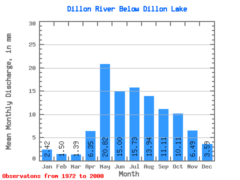
| Statistic | Jan | Feb | Mar | Apr | May | Jun | Jul | Aug | Sep | Oct | Nov | Dec | Annual |
|---|---|---|---|---|---|---|---|---|---|---|---|---|---|
| Mean | 2.42 | 1.51 | 1.39 | 6.35 | 20.81 | 15.00 | 15.72 | 13.94 | 11.11 | 10.11 | 6.49 | 3.59 | 106.78 |
| Standard Deviation | 1.91 | 1.11 | 0.89 | 4.71 | 19.39 | 10.24 | 11.88 | 12.53 | 9.42 | 7.87 | 4.27 | 2.14 | 56.33 |
| Min | 0.72 | 0.42 | 0.43 | 2.00 | 3.47 | 1.20 | 1.40 | 0.97 | 1.25 | 1.48 | 1.00 | 0.75 | 30.96 |
| Max | 10.16 | 5.99 | 4.92 | 23.14 | 84.82 | 36.16 | 45.52 | 62.06 | 34.71 | 32.30 | 18.58 | 10.09 | 231.84 |
| Coefficient of Variation | 0.79 | 0.74 | 0.64 | 0.74 | 0.93 | 0.68 | 0.76 | 0.90 | 0.85 | 0.78 | 0.66 | 0.59 | 0.53 |
 Return to R-Arctic Net Home Page