|
|
|||||||||||||||||
| Point ID: 5571 | Downloads | Plots | Site Data | Code: 06AD010 |
|
|
|||||||||||||||||
| Download | |
|---|---|
| Site Descriptor Information | Site Time Series Data |
| Link to all available data | |
| View: | Time Series | All |
| Units: | mm |
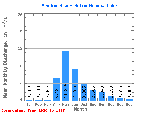
| Statistic | Jan | Feb | Mar | Apr | May | Jun | Jul | Aug | Sep | Oct | Nov | Dec | Annual |
|---|---|---|---|---|---|---|---|---|---|---|---|---|---|
| Mean | 0.17 | 0.12 | 0.30 | 5.18 | 11.35 | 7.20 | 3.91 | 2.50 | 1.95 | 1.13 | 0.69 | 0.36 | 2.35 |
| Standard Deviation | 0.23 | 0.20 | 0.45 | 6.50 | 11.72 | 6.91 | 3.84 | 2.64 | 3.27 | 1.19 | 0.73 | 0.35 | 1.42 |
| Min | 0.00 | 0.00 | 0.00 | 0.92 | 1.27 | 0.73 | 0.16 | 0.03 | 0.00 | 0.00 | 0.00 | 0.00 | 0.57 |
| Max | 0.59 | 0.73 | 1.84 | 30.60 | 49.00 | 25.70 | 14.90 | 9.30 | 16.20 | 5.39 | 2.69 | 1.05 | 5.62 |
| Coefficient of Variation | 1.39 | 1.67 | 1.48 | 1.25 | 1.03 | 0.96 | 0.98 | 1.05 | 1.68 | 1.05 | 1.05 | 0.97 | 0.60 |
 Return to R-Arctic Net Home Page