|
|
|||||||||||||||||
| Point ID: 5571 | Downloads | Plots | Site Data | Code: 06AD010 |
|
|
|||||||||||||||||
| Download | |
|---|---|
| Site Descriptor Information | Site Time Series Data |
| Link to all available data | |
| View: | Time Series | All |
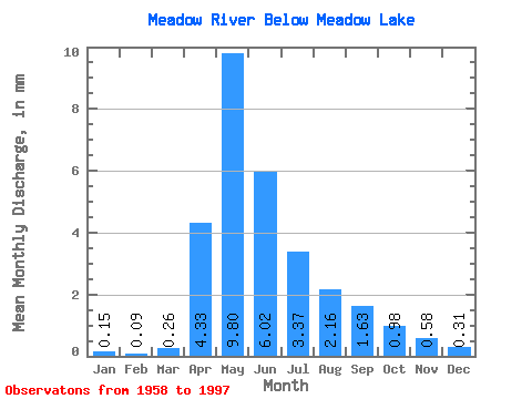
| Units: | m3/s |
| Statistic | Jan | Feb | Mar | Apr | May | Jun | Jul | Aug | Sep | Oct | Nov | Dec | Annual |
|---|---|---|---|---|---|---|---|---|---|---|---|---|---|
| Mean | 0.14 | 0.09 | 0.24 | 4.02 | 9.10 | 5.59 | 3.13 | 2.01 | 1.51 | 0.91 | 0.54 | 0.29 | 22.20 |
| Standard Deviation | 0.19 | 0.14 | 0.36 | 5.05 | 9.39 | 5.36 | 3.08 | 2.11 | 2.53 | 0.95 | 0.57 | 0.28 | 13.43 |
| Min | 0.00 | 0.00 | 0.00 | 0.71 | 1.02 | 0.57 | 0.13 | 0.02 | 0.00 | 0.00 | 0.00 | 0.00 | 5.43 |
| Max | 0.48 | 0.53 | 1.48 | 23.75 | 39.29 | 19.94 | 11.95 | 7.46 | 12.57 | 4.32 | 2.09 | 0.84 | 53.06 |
| Coefficient of Variation | 1.39 | 1.67 | 1.48 | 1.25 | 1.03 | 0.96 | 0.98 | 1.05 | 1.68 | 1.05 | 1.05 | 0.97 | 0.60 |
 Return to R-Arctic Net Home Page