|
|
|||||||||||||||||
| Point ID: 5560 | Downloads | Plots | Site Data | Code: 05NF006 |
|
|
|||||||||||||||||
| Download | |
|---|---|
| Site Descriptor Information | Site Time Series Data |
| Link to all available data | |
| View: | Time Series | All |
| Units: | mm |
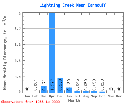
| Statistic | Jan | Feb | Mar | Apr | May | Jun | Jul | Aug | Sep | Oct | Nov | Dec | Annual |
|---|---|---|---|---|---|---|---|---|---|---|---|---|---|
| Mean | 0.00 | 0.17 | 1.98 | 0.38 | 0.13 | 0.04 | 0.05 | 0.05 | 0.03 | ||||
| Standard Deviation | 0.36 | 3.77 | 0.83 | 0.35 | 0.10 | 0.24 | 0.17 | 0.09 | |||||
| Min | 0.00 | 0.00 | 0.00 | 0.00 | 0.00 | 0.00 | 0.00 | 0.00 | 0.00 | ||||
| Max | 0.00 | 1.20 | 18.30 | 3.68 | 1.47 | 0.33 | 1.26 | 0.73 | 0.36 | ||||
| Coefficient of Variation | 2.10 | 1.91 | 2.20 | 2.72 | 2.16 | 4.82 | 3.40 | 3.22 |
 Return to R-Arctic Net Home Page