|
|
|||||||||||||||||
| Point ID: 5560 | Downloads | Plots | Site Data | Code: 05NF006 |
|
|
|||||||||||||||||
| Download | |
|---|---|
| Site Descriptor Information | Site Time Series Data |
| Link to all available data | |
| View: | Time Series | All |
| Units: | m3/s |
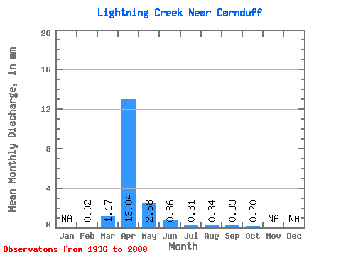
| Statistic | Jan | Feb | Mar | Apr | May | Jun | Jul | Aug | Sep | Oct | Nov | Dec | Annual |
|---|---|---|---|---|---|---|---|---|---|---|---|---|---|
| Mean | 0.01 | 0.62 | 6.92 | 1.37 | 0.45 | 0.16 | 0.18 | 0.18 | 0.11 | ||||
| Standard Deviation | 1.30 | 13.21 | 3.02 | 1.24 | 0.35 | 0.88 | 0.60 | 0.34 | |||||
| Min | 0.01 | 0.00 | 0.00 | 0.00 | 0.00 | 0.00 | 0.00 | 0.00 | 0.00 | ||||
| Max | 0.01 | 4.34 | 64.10 | 13.32 | 5.15 | 1.18 | 4.56 | 2.56 | 1.32 | ||||
| Coefficient of Variation | 2.10 | 1.91 | 2.20 | 2.72 | 2.16 | 4.82 | 3.40 | 3.22 |
 Return to R-Arctic Net Home Page