|
|
|||||||||||||||||
| Point ID: 5558 | Downloads | Plots | Site Data | Code: 05NE001 |
|
|
|||||||||||||||||
| Download | |
|---|---|
| Site Descriptor Information | Site Time Series Data |
| Link to all available data | |
| View: | Time Series | All |
| Units: | mm |
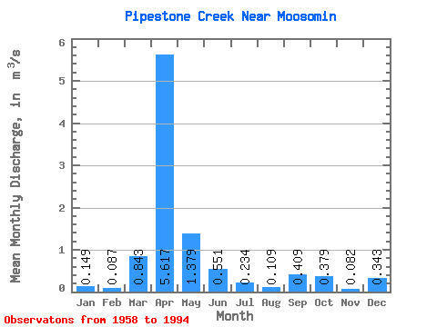
| Statistic | Jan | Feb | Mar | Apr | May | Jun | Jul | Aug | Sep | Oct | Nov | Dec | Annual |
|---|---|---|---|---|---|---|---|---|---|---|---|---|---|
| Mean | 0.15 | 0.09 | 0.84 | 5.62 | 1.38 | 0.55 | 0.23 | 0.11 | 0.41 | 0.38 | 0.08 | 0.34 | |
| Standard Deviation | 1.63 | 9.33 | 2.40 | 1.48 | 0.43 | 0.13 | 0.96 | 0.63 | 0.10 | ||||
| Min | 0.15 | 0.09 | 0.01 | 0.00 | 0.00 | 0.00 | 0.00 | 0.00 | 0.00 | 0.00 | 0.01 | 0.34 | |
| Max | 0.15 | 0.09 | 6.51 | 53.90 | 10.00 | 8.59 | 2.36 | 0.57 | 5.65 | 3.38 | 0.15 | 0.34 | |
| Coefficient of Variation | 1.93 | 1.66 | 1.74 | 2.69 | 1.83 | 1.21 | 2.34 | 1.66 | 1.21 |
 Return to R-Arctic Net Home Page