|
|
|||||||||||||||||
| Point ID: 5558 | Downloads | Plots | Site Data | Code: 05NE001 |
|
|
|||||||||||||||||
| Download | |
|---|---|
| Site Descriptor Information | Site Time Series Data |
| Link to all available data | |
| View: | Time Series | All |
| Units: | m3/s |
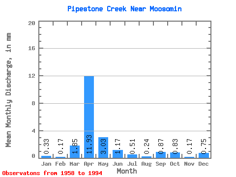
| Statistic | Jan | Feb | Mar | Apr | May | Jun | Jul | Aug | Sep | Oct | Nov | Dec | Annual |
|---|---|---|---|---|---|---|---|---|---|---|---|---|---|
| Mean | 0.11 | 0.06 | 0.62 | 3.99 | 1.01 | 0.39 | 0.17 | 0.08 | 0.29 | 0.28 | 0.06 | 0.25 | |
| Standard Deviation | 1.19 | 6.63 | 1.76 | 1.05 | 0.31 | 0.10 | 0.68 | 0.46 | 0.07 | ||||
| Min | 0.11 | 0.06 | 0.00 | 0.00 | 0.00 | 0.00 | 0.00 | 0.00 | 0.00 | 0.00 | 0.01 | 0.25 | |
| Max | 0.11 | 0.06 | 4.78 | 38.28 | 7.34 | 6.10 | 1.73 | 0.42 | 4.01 | 2.48 | 0.11 | 0.25 | |
| Coefficient of Variation | 1.93 | 1.66 | 1.74 | 2.69 | 1.83 | 1.21 | 2.34 | 1.66 | 1.21 |
 Return to R-Arctic Net Home Page