|
|
|||||||||||||||||
| Point ID: 5539 | Downloads | Plots | Site Data | Code: 05NB027 |
|
|
|||||||||||||||||
| Download | |
|---|---|
| Site Descriptor Information | Site Time Series Data |
| Link to all available data | |
| View: | Time Series | All |
| Units: | mm |
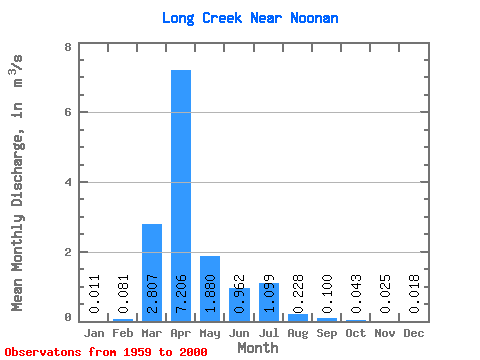
| Statistic | Jan | Feb | Mar | Apr | May | Jun | Jul | Aug | Sep | Oct | Nov | Dec | Annual |
|---|---|---|---|---|---|---|---|---|---|---|---|---|---|
| Mean | 0.01 | 0.08 | 2.81 | 7.21 | 1.88 | 0.96 | 1.10 | 0.23 | 0.10 | 0.04 | 0.03 | 0.02 | 1.21 |
| Standard Deviation | 0.03 | 0.33 | 4.81 | 10.96 | 4.19 | 2.11 | 2.41 | 0.62 | 0.35 | 0.14 | 0.04 | 0.03 | 1.36 |
| Min | 0.00 | 0.00 | 0.00 | 0.00 | 0.00 | 0.00 | 0.00 | 0.00 | 0.00 | 0.00 | 0.00 | 0.00 | 0.00 |
| Max | 0.14 | 2.02 | 17.00 | 39.50 | 20.60 | 10.60 | 12.80 | 3.71 | 2.19 | 0.88 | 0.20 | 0.12 | 5.65 |
| Coefficient of Variation | 2.39 | 4.02 | 1.71 | 1.52 | 2.23 | 2.19 | 2.19 | 2.70 | 3.50 | 3.27 | 1.84 | 1.79 | 1.13 |
 Return to R-Arctic Net Home Page