|
|
|||||||||||||||||
| Point ID: 5539 | Downloads | Plots | Site Data | Code: 05NB027 |
|
|
|||||||||||||||||
| Download | |
|---|---|
| Site Descriptor Information | Site Time Series Data |
| Link to all available data | |
| View: | Time Series | All |
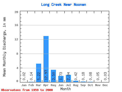
| Units: | m3/s |
| Statistic | Jan | Feb | Mar | Apr | May | Jun | Jul | Aug | Sep | Oct | Nov | Dec | Annual |
|---|---|---|---|---|---|---|---|---|---|---|---|---|---|
| Mean | 0.01 | 0.04 | 1.69 | 4.19 | 1.13 | 0.56 | 0.66 | 0.14 | 0.06 | 0.03 | 0.01 | 0.01 | 8.53 |
| Standard Deviation | 0.02 | 0.18 | 2.89 | 6.37 | 2.52 | 1.23 | 1.45 | 0.37 | 0.20 | 0.09 | 0.03 | 0.02 | 9.65 |
| Min | 0.00 | 0.00 | 0.00 | 0.00 | 0.00 | 0.00 | 0.00 | 0.00 | 0.00 | 0.00 | 0.00 | 0.00 | 0.00 |
| Max | 0.09 | 1.10 | 10.21 | 22.96 | 12.37 | 6.16 | 7.69 | 2.23 | 1.27 | 0.53 | 0.12 | 0.07 | 40.00 |
| Coefficient of Variation | 2.39 | 4.02 | 1.71 | 1.52 | 2.23 | 2.19 | 2.19 | 2.70 | 3.50 | 3.27 | 1.84 | 1.79 | 1.13 |
 Return to R-Arctic Net Home Page