|
|
|||||||||||||||||
| Point ID: 5519 | Downloads | Plots | Site Data | Code: 05NA004 |
|
|
|||||||||||||||||
| Download | |
|---|---|
| Site Descriptor Information | Site Time Series Data |
| Link to all available data | |
| View: | Time Series | All |
| Units: | mm |
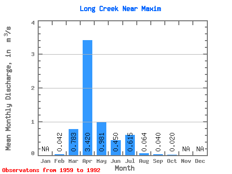
| Statistic | Jan | Feb | Mar | Apr | May | Jun | Jul | Aug | Sep | Oct | Nov | Dec | Annual |
|---|---|---|---|---|---|---|---|---|---|---|---|---|---|
| Mean | 0.04 | 0.78 | 3.42 | 0.98 | 0.45 | 0.61 | 0.06 | 0.04 | 0.02 | ||||
| Standard Deviation | 0.01 | 1.91 | 5.55 | 2.35 | 1.27 | 2.34 | 0.12 | 0.14 | 0.07 | ||||
| Min | 0.04 | 0.00 | 0.00 | 0.00 | 0.00 | 0.00 | 0.00 | 0.00 | 0.00 | ||||
| Max | 0.05 | 8.01 | 20.40 | 10.60 | 6.68 | 13.20 | 0.40 | 0.72 | 0.39 | ||||
| Coefficient of Variation | 0.22 | 2.44 | 1.62 | 2.39 | 2.83 | 3.81 | 1.93 | 3.55 | 3.63 |
 Return to R-Arctic Net Home Page