|
|
|||||||||||||||||
| Point ID: 5519 | Downloads | Plots | Site Data | Code: 05NA004 |
|
|
|||||||||||||||||
| Download | |
|---|---|
| Site Descriptor Information | Site Time Series Data |
| Link to all available data | |
| View: | Time Series | All |
| Units: | m3/s |
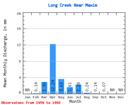
| Statistic | Jan | Feb | Mar | Apr | May | Jun | Jul | Aug | Sep | Oct | Nov | Dec | Annual |
|---|---|---|---|---|---|---|---|---|---|---|---|---|---|
| Mean | 0.06 | 1.17 | 4.95 | 1.47 | 0.65 | 0.92 | 0.10 | 0.06 | 0.03 | ||||
| Standard Deviation | 0.01 | 2.85 | 8.04 | 3.51 | 1.85 | 3.50 | 0.19 | 0.21 | 0.11 | ||||
| Min | 0.05 | 0.00 | 0.00 | 0.00 | 0.00 | 0.00 | 0.00 | 0.00 | 0.00 | ||||
| Max | 0.07 | 11.98 | 29.54 | 15.86 | 9.67 | 19.75 | 0.60 | 1.05 | 0.59 | ||||
| Coefficient of Variation | 0.22 | 2.44 | 1.62 | 2.39 | 2.83 | 3.81 | 1.93 | 3.55 | 3.63 |
 Return to R-Arctic Net Home Page