|
|
|||||||||||||||||
| Point ID: 5502 | Downloads | Plots | Site Data | Code: 05MB005 |
|
|
|||||||||||||||||
| Download | |
|---|---|
| Site Descriptor Information | Site Time Series Data |
| Link to all available data | |
| View: | Time Series | All |
| Units: | mm |
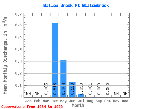
| Statistic | Jan | Feb | Mar | Apr | May | Jun | Jul | Aug | Sep | Oct | Nov | Dec | Annual |
|---|---|---|---|---|---|---|---|---|---|---|---|---|---|
| Mean | 0.01 | 0.61 | 0.31 | 0.13 | 0.03 | 0.00 | 0.00 | 0.00 | |||||
| Standard Deviation | 0.03 | 0.93 | 0.57 | 0.31 | 0.09 | 0.00 | 0.00 | 0.00 | |||||
| Min | 0.00 | 0.00 | 0.00 | 0.00 | 0.00 | 0.00 | 0.00 | 0.00 | |||||
| Max | 0.13 | 3.53 | 2.30 | 1.46 | 0.43 | 0.01 | 0.01 | 0.00 | |||||
| Coefficient of Variation | 4.91 | 1.50 | 1.84 | 2.37 | 2.89 | 3.57 | 5.38 | 5.38 |
 Return to R-Arctic Net Home Page