|
|
|||||||||||||||||
| Point ID: 5502 | Downloads | Plots | Site Data | Code: 05MB005 |
|
|
|||||||||||||||||
| Download | |
|---|---|
| Site Descriptor Information | Site Time Series Data |
| Link to all available data | |
| View: | Time Series | All |
| Units: | m3/s |
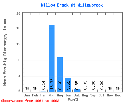
| Statistic | Jan | Feb | Mar | Apr | May | Jun | Jul | Aug | Sep | Oct | Nov | Dec | Annual |
|---|---|---|---|---|---|---|---|---|---|---|---|---|---|
| Mean | 0.03 | 3.96 | 2.05 | 0.83 | 0.20 | 0.01 | 0.00 | 0.00 | |||||
| Standard Deviation | 0.17 | 5.96 | 3.78 | 1.97 | 0.59 | 0.02 | 0.01 | 0.00 | |||||
| Min | 0.00 | 0.00 | 0.00 | 0.00 | 0.00 | 0.00 | 0.00 | 0.00 | |||||
| Max | 0.89 | 22.76 | 15.32 | 9.41 | 2.88 | 0.10 | 0.04 | 0.01 | |||||
| Coefficient of Variation | 4.91 | 1.50 | 1.84 | 2.37 | 2.89 | 3.57 | 5.38 | 5.38 |
 Return to R-Arctic Net Home Page