|
|
|||||||||||||||||
| Point ID: 5485 | Downloads | Plots | Site Data | Code: 05MA012 |
|
|
|||||||||||||||||
| Download | |
|---|---|
| Site Descriptor Information | Site Time Series Data |
| Link to all available data | |
| View: | Time Series | All |
| Units: | mm |
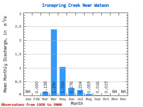
| Statistic | Jan | Feb | Mar | Apr | May | Jun | Jul | Aug | Sep | Oct | Nov | Dec | Annual |
|---|---|---|---|---|---|---|---|---|---|---|---|---|---|
| Mean | 0.00 | 0.14 | 2.39 | 1.03 | 0.28 | 0.20 | 0.06 | 0.02 | 0.02 | ||||
| Standard Deviation | 0.00 | 0.30 | 2.86 | 1.40 | 0.31 | 0.65 | 0.14 | 0.05 | 0.04 | ||||
| Min | 0.00 | 0.00 | 0.01 | 0.00 | 0.00 | 0.00 | 0.00 | 0.00 | 0.00 | ||||
| Max | 0.00 | 1.35 | 12.10 | 4.95 | 1.30 | 3.91 | 0.60 | 0.29 | 0.16 | ||||
| Coefficient of Variation | 2.15 | 1.20 | 1.35 | 1.14 | 3.19 | 2.44 | 3.05 | 1.86 |
 Return to R-Arctic Net Home Page