|
|
|||||||||||||||||
| Point ID: 5485 | Downloads | Plots | Site Data | Code: 05MA012 |
|
|
|||||||||||||||||
| Download | |
|---|---|
| Site Descriptor Information | Site Time Series Data |
| Link to all available data | |
| View: | Time Series | All |
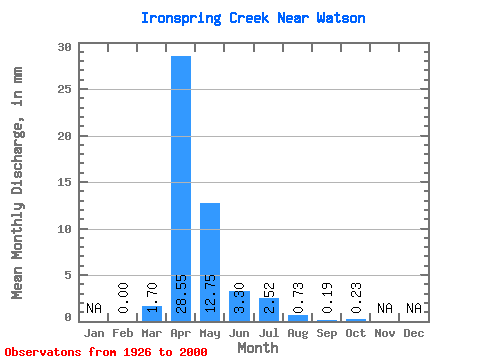
| Units: | m3/s |
| Statistic | Jan | Feb | Mar | Apr | May | Jun | Jul | Aug | Sep | Oct | Nov | Dec | Annual |
|---|---|---|---|---|---|---|---|---|---|---|---|---|---|
| Mean | 0.00 | 0.63 | 10.54 | 4.70 | 1.22 | 0.93 | 0.27 | 0.07 | 0.08 | ||||
| Standard Deviation | 0.00 | 1.35 | 12.61 | 6.37 | 1.39 | 2.97 | 0.65 | 0.21 | 0.16 | ||||
| Min | 0.00 | 0.00 | 0.06 | 0.01 | 0.00 | 0.00 | 0.00 | 0.00 | 0.00 | ||||
| Max | 0.00 | 6.15 | 53.34 | 22.54 | 5.73 | 17.81 | 2.75 | 1.28 | 0.74 | ||||
| Coefficient of Variation | 2.15 | 1.20 | 1.35 | 1.14 | 3.19 | 2.44 | 3.05 | 1.86 |
 Return to R-Arctic Net Home Page