|
|
|||||||||||||||||
| Point ID: 5460 | Downloads | Plots | Site Data | Code: 05KJ014 |
|
|
|||||||||||||||||
| Download | |
|---|---|
| Site Descriptor Information | Site Time Series Data |
| Link to all available data | |
| View: | Time Series | All |
| Units: | mm |
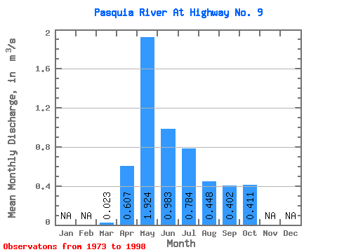
| Statistic | Jan | Feb | Mar | Apr | May | Jun | Jul | Aug | Sep | Oct | Nov | Dec | Annual |
|---|---|---|---|---|---|---|---|---|---|---|---|---|---|
| Mean | 0.02 | 0.61 | 1.92 | 0.98 | 0.78 | 0.45 | 0.40 | 0.41 | |||||
| Standard Deviation | 0.03 | 0.48 | 1.26 | 0.65 | 1.00 | 0.60 | 0.35 | 0.27 | |||||
| Min | 0.00 | 0.04 | 0.25 | 0.06 | 0.09 | 0.03 | 0.02 | 0.06 | |||||
| Max | 0.09 | 2.19 | 4.81 | 2.75 | 5.14 | 2.64 | 1.33 | 1.14 | |||||
| Coefficient of Variation | 1.20 | 0.79 | 0.66 | 0.66 | 1.27 | 1.33 | 0.88 | 0.65 |
 Return to R-Arctic Net Home Page