|
|
|||||||||||||||||
| Point ID: 5460 | Downloads | Plots | Site Data | Code: 05KJ014 |
|
|
|||||||||||||||||
| Download | |
|---|---|
| Site Descriptor Information | Site Time Series Data |
| Link to all available data | |
| View: | Time Series | All |
| Units: | m3/s |
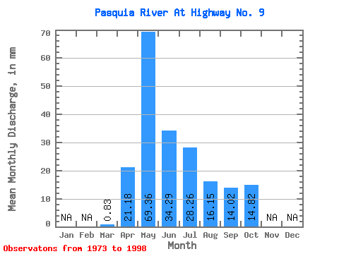
| Statistic | Jan | Feb | Mar | Apr | May | Jun | Jul | Aug | Sep | Oct | Nov | Dec | Annual |
|---|---|---|---|---|---|---|---|---|---|---|---|---|---|
| Mean | 0.82 | 21.19 | 69.36 | 34.29 | 28.26 | 16.16 | 14.04 | 14.82 | |||||
| Standard Deviation | 0.99 | 16.76 | 45.55 | 22.65 | 36.03 | 21.55 | 12.38 | 9.62 | |||||
| Min | 0.00 | 1.43 | 8.97 | 2.13 | 3.06 | 0.90 | 0.59 | 2.02 | |||||
| Max | 3.10 | 76.40 | 173.37 | 95.94 | 185.26 | 95.15 | 46.40 | 41.09 | |||||
| Coefficient of Variation | 1.20 | 0.79 | 0.66 | 0.66 | 1.27 | 1.33 | 0.88 | 0.65 |
 Return to R-Arctic Net Home Page