|
|
|||||||||||||||||
| Point ID: 5437 | Downloads | Plots | Site Data | Code: 05KC001 |
|
|
|||||||||||||||||
| Download | |
|---|---|
| Site Descriptor Information | Site Time Series Data |
| Link to all available data | |
| View: | Time Series | All |
| Units: | mm |
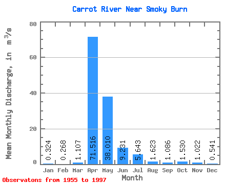
| Statistic | Jan | Feb | Mar | Apr | May | Jun | Jul | Aug | Sep | Oct | Nov | Dec | Annual |
|---|---|---|---|---|---|---|---|---|---|---|---|---|---|
| Mean | 0.32 | 0.27 | 1.11 | 71.52 | 38.01 | 9.23 | 5.64 | 1.62 | 1.09 | 1.53 | 1.02 | 0.54 | 9.42 |
| Standard Deviation | 0.15 | 0.13 | 3.25 | 52.06 | 49.58 | 10.94 | 11.31 | 2.20 | 1.13 | 1.56 | 0.93 | 0.25 | 7.92 |
| Min | 0.06 | 0.04 | 0.03 | 3.63 | 0.86 | 0.19 | 0.07 | 0.04 | 0.01 | 0.07 | 0.09 | 0.13 | 1.08 |
| Max | 0.54 | 0.51 | 20.60 | 203.00 | 205.00 | 40.00 | 69.50 | 10.20 | 5.65 | 6.77 | 3.92 | 1.22 | 30.37 |
| Coefficient of Variation | 0.45 | 0.47 | 2.93 | 0.73 | 1.30 | 1.19 | 2.00 | 1.35 | 1.04 | 1.02 | 0.91 | 0.47 | 0.84 |
 Return to R-Arctic Net Home Page