|
|
|||||||||||||||||
| Point ID: 5437 | Downloads | Plots | Site Data | Code: 05KC001 |
|
|
|||||||||||||||||
| Download | |
|---|---|
| Site Descriptor Information | Site Time Series Data |
| Link to all available data | |
| View: | Time Series | All |
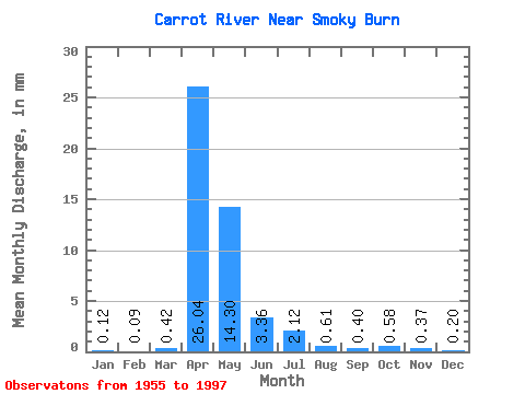
| Units: | m3/s |
| Statistic | Jan | Feb | Mar | Apr | May | Jun | Jul | Aug | Sep | Oct | Nov | Dec | Annual |
|---|---|---|---|---|---|---|---|---|---|---|---|---|---|
| Mean | 0.09 | 0.07 | 0.32 | 20.04 | 11.00 | 2.59 | 1.63 | 0.47 | 0.30 | 0.44 | 0.29 | 0.16 | 32.13 |
| Standard Deviation | 0.04 | 0.03 | 0.94 | 14.59 | 14.35 | 3.06 | 3.27 | 0.64 | 0.32 | 0.45 | 0.26 | 0.07 | 27.01 |
| Min | 0.02 | 0.01 | 0.01 | 1.02 | 0.25 | 0.05 | 0.02 | 0.01 | 0.00 | 0.02 | 0.02 | 0.04 | 3.69 |
| Max | 0.16 | 0.14 | 5.96 | 56.88 | 59.35 | 11.21 | 20.12 | 2.95 | 1.58 | 1.96 | 1.10 | 0.35 | 103.61 |
| Coefficient of Variation | 0.45 | 0.47 | 2.93 | 0.73 | 1.30 | 1.19 | 2.00 | 1.35 | 1.04 | 1.02 | 0.91 | 0.47 | 0.84 |
 Return to R-Arctic Net Home Page