|
|
|||||||||||||||||
| Point ID: 5426 | Downloads | Plots | Site Data | Code: 05KB003 |
|
|
|||||||||||||||||
| Download | |
|---|---|
| Site Descriptor Information | Site Time Series Data |
| Link to all available data | |
| View: | Time Series | All |
| Units: | mm |
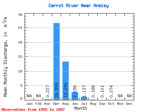
| Statistic | Jan | Feb | Mar | Apr | May | Jun | Jul | Aug | Sep | Oct | Nov | Dec | Annual |
|---|---|---|---|---|---|---|---|---|---|---|---|---|---|
| Mean | 0.23 | 26.59 | 13.29 | 2.70 | 1.14 | 0.19 | 0.10 | 0.07 | |||||
| Standard Deviation | 1.00 | 23.93 | 19.45 | 4.85 | 2.54 | 0.43 | 0.30 | 0.23 | |||||
| Min | 0.00 | 0.17 | 0.00 | 0.00 | 0.00 | 0.00 | 0.00 | 0.00 | |||||
| Max | 6.51 | 91.80 | 72.50 | 19.80 | 11.90 | 2.56 | 1.64 | 1.34 | |||||
| Coefficient of Variation | 4.40 | 0.90 | 1.46 | 1.80 | 2.23 | 2.31 | 2.96 | 3.06 |
 Return to R-Arctic Net Home Page