|
|
|||||||||||||||||
| Point ID: 5426 | Downloads | Plots | Site Data | Code: 05KB003 |
|
|
|||||||||||||||||
| Download | |
|---|---|
| Site Descriptor Information | Site Time Series Data |
| Link to all available data | |
| View: | Time Series | All |
| Units: | m3/s |
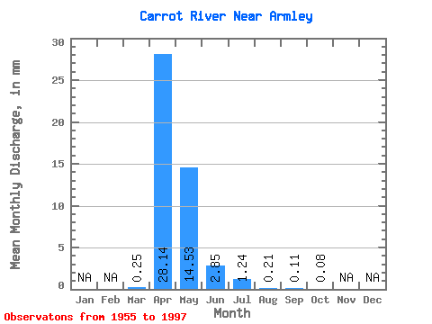
| Statistic | Jan | Feb | Mar | Apr | May | Jun | Jul | Aug | Sep | Oct | Nov | Dec | Annual |
|---|---|---|---|---|---|---|---|---|---|---|---|---|---|
| Mean | 0.14 | 15.67 | 8.09 | 1.59 | 0.69 | 0.12 | 0.06 | 0.04 | |||||
| Standard Deviation | 0.61 | 14.10 | 11.84 | 2.86 | 1.54 | 0.26 | 0.17 | 0.14 | |||||
| Min | 0.00 | 0.10 | 0.00 | 0.00 | 0.00 | 0.00 | 0.00 | 0.00 | |||||
| Max | 3.96 | 54.08 | 44.13 | 11.66 | 7.24 | 1.56 | 0.97 | 0.82 | |||||
| Coefficient of Variation | 4.40 | 0.90 | 1.46 | 1.80 | 2.23 | 2.31 | 2.96 | 3.06 |
 Return to R-Arctic Net Home Page