|
|
|||||||||||||||||
| Point ID: 5406 | Downloads | Plots | Site Data | Code: 05JL005 |
|
|
|||||||||||||||||
| Download | |
|---|---|
| Site Descriptor Information | Site Time Series Data |
| Link to all available data | |
| View: | Time Series | All |
| Units: | mm |
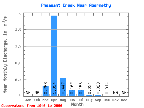
| Statistic | Jan | Feb | Mar | Apr | May | Jun | Jul | Aug | Sep | Oct | Nov | Dec | Annual |
|---|---|---|---|---|---|---|---|---|---|---|---|---|---|
| Mean | 0.26 | 1.93 | 0.45 | 0.16 | 0.16 | 0.03 | 0.03 | 0.01 | |||||
| Standard Deviation | 0.47 | 2.34 | 1.39 | 0.46 | 0.60 | 0.12 | 0.19 | 0.09 | |||||
| Min | 0.00 | 0.00 | 0.00 | 0.00 | 0.00 | 0.00 | 0.00 | 0.00 | |||||
| Max | 2.18 | 10.10 | 9.34 | 2.76 | 3.88 | 0.56 | 1.43 | 0.68 | |||||
| Coefficient of Variation | 1.82 | 1.21 | 3.12 | 2.83 | 3.85 | 3.46 | 6.71 | 6.62 |
 Return to R-Arctic Net Home Page