|
|
|||||||||||||||||
| Point ID: 5401 | Downloads | Plots | Site Data | Code: 05JK007 |
|
|
|||||||||||||||||
| Download | |
|---|---|
| Site Descriptor Information | Site Time Series Data |
| Link to all available data | |
| View: | Time Series | All |
| Units: | mm |
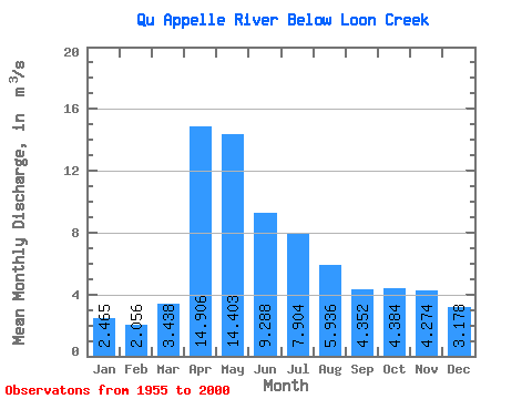
| Statistic | Jan | Feb | Mar | Apr | May | Jun | Jul | Aug | Sep | Oct | Nov | Dec | Annual |
|---|---|---|---|---|---|---|---|---|---|---|---|---|---|
| Mean | 2.46 | 2.06 | 3.44 | 14.91 | 14.40 | 9.29 | 7.90 | 5.94 | 4.35 | 4.38 | 4.27 | 3.18 | 5.97 |
| Standard Deviation | 1.63 | 1.34 | 2.79 | 16.45 | 15.54 | 10.78 | 8.38 | 6.37 | 4.55 | 3.59 | 2.88 | 1.93 | 5.32 |
| Min | 0.50 | 0.14 | 0.58 | 0.77 | 0.21 | 0.50 | 0.20 | 0.30 | 0.19 | 0.05 | 0.51 | 0.43 | 1.06 |
| Max | 7.45 | 5.91 | 14.80 | 55.90 | 51.10 | 38.10 | 28.20 | 24.10 | 20.20 | 15.00 | 12.30 | 8.41 | 19.82 |
| Coefficient of Variation | 0.66 | 0.65 | 0.81 | 1.10 | 1.08 | 1.16 | 1.06 | 1.07 | 1.04 | 0.82 | 0.67 | 0.61 | 0.89 |
 Return to R-Arctic Net Home Page