|
|
|||||||||||||||||
| Point ID: 5401 | Downloads | Plots | Site Data | Code: 05JK007 |
|
|
|||||||||||||||||
| Download | |
|---|---|
| Site Descriptor Information | Site Time Series Data |
| Link to all available data | |
| View: | Time Series | All |
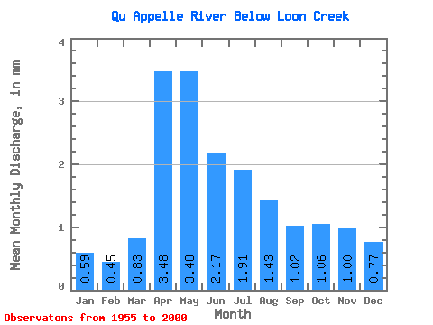
| Units: | m3/s |
| Statistic | Jan | Feb | Mar | Apr | May | Jun | Jul | Aug | Sep | Oct | Nov | Dec | Annual |
|---|---|---|---|---|---|---|---|---|---|---|---|---|---|
| Mean | 0.18 | 0.14 | 0.25 | 1.06 | 1.06 | 0.66 | 0.58 | 0.43 | 0.31 | 0.32 | 0.30 | 0.23 | 5.16 |
| Standard Deviation | 0.12 | 0.09 | 0.20 | 1.17 | 1.14 | 0.77 | 0.61 | 0.47 | 0.32 | 0.26 | 0.20 | 0.14 | 4.60 |
| Min | 0.04 | 0.01 | 0.04 | 0.05 | 0.01 | 0.04 | 0.01 | 0.02 | 0.01 | 0.00 | 0.04 | 0.03 | 0.91 |
| Max | 0.55 | 0.40 | 1.09 | 3.97 | 3.75 | 2.71 | 2.07 | 1.77 | 1.43 | 1.10 | 0.87 | 0.62 | 17.14 |
| Coefficient of Variation | 0.66 | 0.65 | 0.81 | 1.10 | 1.08 | 1.16 | 1.06 | 1.07 | 1.04 | 0.82 | 0.67 | 0.61 | 0.89 |
 Return to R-Arctic Net Home Page