|
|
|||||||||||||||||
| Point ID: 54 | Downloads | Plots | Site Data | Code: 05AB039 |
|
|
|||||||||||||||||
| Download | |
|---|---|
| Site Descriptor Information | Site Time Series Data |
| Link to all available data | |
| View: | Time Series | All |
| Units: | mm |
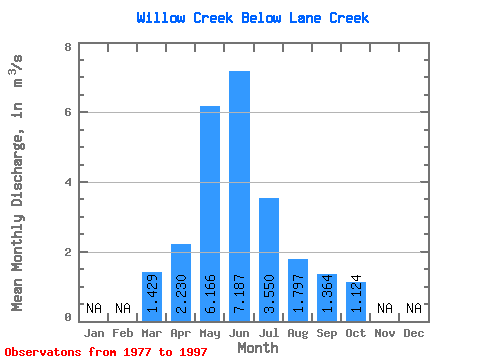
| Statistic | Jan | Feb | Mar | Apr | May | Jun | Jul | Aug | Sep | Oct | Nov | Dec | Annual |
|---|---|---|---|---|---|---|---|---|---|---|---|---|---|
| Mean | 1.43 | 2.23 | 6.17 | 7.19 | 3.55 | 1.80 | 1.36 | 1.12 | |||||
| Standard Deviation | 1.05 | 1.78 | 5.31 | 9.03 | 5.39 | 3.05 | 2.39 | 1.38 | |||||
| Min | 0.48 | 0.51 | 0.37 | 0.55 | 0.27 | 0.20 | 0.14 | 0.26 | |||||
| Max | 3.80 | 7.16 | 17.60 | 38.80 | 23.30 | 14.00 | 11.00 | 6.17 | |||||
| Coefficient of Variation | 0.73 | 0.80 | 0.86 | 1.26 | 1.52 | 1.70 | 1.75 | 1.23 |
 Return to R-Arctic Net Home Page