|
|
|||||||||||||||||
| Point ID: 54 | Downloads | Plots | Site Data | Code: 05AB039 |
|
|
|||||||||||||||||
| Download | |
|---|---|
| Site Descriptor Information | Site Time Series Data |
| Link to all available data | |
| View: | Time Series | All |
| Units: | m3/s |
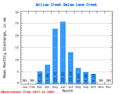
| Statistic | Jan | Feb | Mar | Apr | May | Jun | Jul | Aug | Sep | Oct | Nov | Dec | Annual |
|---|---|---|---|---|---|---|---|---|---|---|---|---|---|
| Mean | 5.27 | 7.95 | 22.71 | 25.63 | 13.08 | 6.62 | 4.86 | 4.14 | |||||
| Standard Deviation | 3.87 | 6.34 | 19.57 | 32.20 | 19.84 | 11.25 | 8.54 | 5.08 | |||||
| Min | 1.78 | 1.81 | 1.38 | 1.94 | 0.99 | 0.74 | 0.50 | 0.97 | |||||
| Max | 14.00 | 25.53 | 64.83 | 138.34 | 85.83 | 51.57 | 39.22 | 22.73 | |||||
| Coefficient of Variation | 0.73 | 0.80 | 0.86 | 1.26 | 1.52 | 1.70 | 1.75 | 1.23 |
 Return to R-Arctic Net Home Page