|
|
|||||||||||||||||
| Point ID: 5398 | Downloads | Plots | Site Data | Code: 05JK002 |
|
|
|||||||||||||||||
| Download | |
|---|---|
| Site Descriptor Information | Site Time Series Data |
| Link to all available data | |
| View: | Time Series | All |
| Units: | mm |
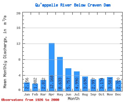
| Statistic | Jan | Feb | Mar | Apr | May | Jun | Jul | Aug | Sep | Oct | Nov | Dec | Annual |
|---|---|---|---|---|---|---|---|---|---|---|---|---|---|
| Mean | 2.16 | 1.88 | 2.81 | 12.17 | 8.63 | 5.76 | 4.99 | 3.69 | 3.00 | 3.17 | 3.58 | 2.72 | 5.17 |
| Standard Deviation | 1.96 | 1.68 | 3.88 | 15.32 | 12.17 | 8.71 | 7.13 | 5.30 | 4.31 | 3.84 | 3.42 | 2.38 | 5.26 |
| Min | 0.02 | 0.02 | 0.00 | 0.14 | 0.00 | 0.00 | 0.00 | 0.01 | 0.00 | 0.00 | 0.02 | 0.02 | 0.29 |
| Max | 7.80 | 5.95 | 23.50 | 60.40 | 49.10 | 36.90 | 30.30 | 23.20 | 19.50 | 15.00 | 14.00 | 10.50 | 20.62 |
| Coefficient of Variation | 0.91 | 0.89 | 1.38 | 1.26 | 1.41 | 1.51 | 1.43 | 1.44 | 1.44 | 1.21 | 0.95 | 0.88 | 1.02 |
 Return to R-Arctic Net Home Page