|
|
|||||||||||||||||
| Point ID: 5397 | Downloads | Plots | Site Data | Code: 05JJ010 |
|
|
|||||||||||||||||
| Download | |
|---|---|
| Site Descriptor Information | Site Time Series Data |
| Link to all available data | |
| View: | Time Series | All |
| Units: | mm |
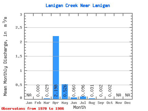
| Statistic | Jan | Feb | Mar | Apr | May | Jun | Jul | Aug | Sep | Oct | Nov | Dec | Annual |
|---|---|---|---|---|---|---|---|---|---|---|---|---|---|
| Mean | 0.00 | 0.03 | 2.20 | 0.53 | 0.06 | 0.10 | 0.03 | 0.00 | 0.00 | ||||
| Standard Deviation | 0.09 | 2.37 | 0.65 | 0.08 | 0.25 | 0.09 | 0.00 | 0.00 | |||||
| Min | 0.00 | 0.00 | 0.00 | 0.00 | 0.00 | 0.00 | 0.00 | 0.00 | 0.00 | ||||
| Max | 0.00 | 0.32 | 8.30 | 2.09 | 0.26 | 0.89 | 0.33 | 0.01 | 0.01 | ||||
| Coefficient of Variation | 3.13 | 1.08 | 1.23 | 1.30 | 2.63 | 3.04 | 1.44 | 1.15 |
 Return to R-Arctic Net Home Page