|
|
|||||||||||||||||
| Point ID: 5397 | Downloads | Plots | Site Data | Code: 05JJ010 |
|
|
|||||||||||||||||
| Download | |
|---|---|
| Site Descriptor Information | Site Time Series Data |
| Link to all available data | |
| View: | Time Series | All |
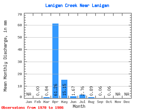
| Units: | m3/s |
| Statistic | Jan | Feb | Mar | Apr | May | Jun | Jul | Aug | Sep | Oct | Nov | Dec | Annual |
|---|---|---|---|---|---|---|---|---|---|---|---|---|---|
| Mean | 0.00 | 0.13 | 9.69 | 2.40 | 0.26 | 0.44 | 0.14 | 0.01 | 0.01 | ||||
| Standard Deviation | 0.41 | 10.44 | 2.96 | 0.34 | 1.15 | 0.42 | 0.01 | 0.01 | |||||
| Min | 0.00 | 0.00 | 0.00 | 0.00 | 0.00 | 0.00 | 0.00 | 0.00 | 0.00 | ||||
| Max | 0.00 | 1.44 | 36.59 | 9.52 | 1.12 | 4.04 | 1.48 | 0.04 | 0.02 | ||||
| Coefficient of Variation | 3.13 | 1.08 | 1.23 | 1.30 | 2.63 | 3.04 | 1.44 | 1.15 |
 Return to R-Arctic Net Home Page