|
|
|||||||||||||||||
| Point ID: 5380 | Downloads | Plots | Site Data | Code: 05JG007 |
|
|
|||||||||||||||||
| Download | |
|---|---|
| Site Descriptor Information | Site Time Series Data |
| Link to all available data | |
| View: | Time Series | All |
| Units: | mm |
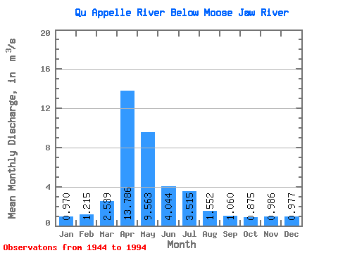
| Statistic | Jan | Feb | Mar | Apr | May | Jun | Jul | Aug | Sep | Oct | Nov | Dec | Annual |
|---|---|---|---|---|---|---|---|---|---|---|---|---|---|
| Mean | 0.97 | 1.22 | 2.54 | 13.79 | 9.56 | 4.04 | 3.52 | 1.55 | 1.06 | 0.88 | 0.99 | 0.98 | 4.24 |
| Standard Deviation | 0.98 | 1.39 | 5.88 | 18.20 | 13.16 | 5.43 | 5.34 | 2.24 | 1.42 | 1.10 | 0.67 | 0.82 | 2.95 |
| Min | 0.46 | 0.45 | 0.00 | 0.15 | 0.03 | 0.00 | 0.00 | 0.00 | 0.00 | 0.00 | 0.30 | 0.43 | 1.00 |
| Max | 4.84 | 5.57 | 41.00 | 82.00 | 62.40 | 32.20 | 30.20 | 12.70 | 7.08 | 3.97 | 3.76 | 3.92 | 14.21 |
| Coefficient of Variation | 1.01 | 1.15 | 2.32 | 1.32 | 1.38 | 1.34 | 1.52 | 1.44 | 1.34 | 1.26 | 0.68 | 0.84 | 0.69 |
 Return to R-Arctic Net Home Page