|
|
|||||||||||||||||
| Point ID: 5373 | Downloads | Plots | Site Data | Code: 05JF012 |
|
|
|||||||||||||||||
| Download | |
|---|---|
| Site Descriptor Information | Site Time Series Data |
| Link to all available data | |
| View: | Time Series | All |
| Units: | mm |
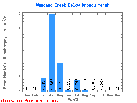
| Statistic | Jan | Feb | Mar | Apr | May | Jun | Jul | Aug | Sep | Oct | Nov | Dec | Annual |
|---|---|---|---|---|---|---|---|---|---|---|---|---|---|
| Mean | 0.89 | 4.86 | 1.79 | 0.15 | 0.75 | 0.13 | 0.01 | 0.00 | |||||
| Standard Deviation | 1.38 | 7.35 | 4.15 | 0.26 | 1.77 | 0.25 | 0.01 | 0.00 | |||||
| Min | 0.00 | 0.02 | 0.00 | 0.00 | 0.00 | 0.00 | 0.00 | 0.00 | |||||
| Max | 4.19 | 25.70 | 16.60 | 1.01 | 7.12 | 0.83 | 0.06 | 0.01 | |||||
| Coefficient of Variation | 1.55 | 1.51 | 2.31 | 1.73 | 2.37 | 1.89 | 2.43 | 1.72 |
 Return to R-Arctic Net Home Page